-

Harry Hayfield wrote a new post, The first named storm of the season has arrived, on the site The Weather of Wales (and other parts of the United Kingdom) 5 years, 7 months ago
A week ago the UK Met Office and Met Éireann (the Met Office for the Republic of Ireland) announced the names of the winter storms for the 2018/2019 season starting off with Ali, then as in the case of the […]

-
Harry Hayfield wrote a new post, Llanrhystud Monthly Summary : July 2018, on the site The Weather of Wales (and other parts of the United Kingdom) 5 years, 8 months ago
Month summarised into a single image:
Average daytime maximum temperature: 69°F (+2°F on long term average)
Maximum maximum daytime temperature: 79°F (July 2nd 2018)
Minimum maximum daytime temperature: 64 […]
-

Thanks for your July summary Harry. Sure have missed your daily updates. I hope you can resume them more regularly in August, assuming you can get your internet connections squared away. I wish I was as “hot” as you were in July – I wasn’t all that bad in the second half with all the clouds and rain we got to keep the temps somewhat in check, but dew point temps stayed mostly in the 70s. Very muggy. Keep up the good work with your records and stay in touch!
Thanks again, Kevin
-
-
Harry Hayfield wrote a new post, Weather Observations: July 10th 2018, on the site The Weather of Wales (and other parts of the United Kingdom) 5 years, 9 months ago
Maximum Temperature: 71°F
Minimum Temperature: 65°F
Temperature at 0800 BST (July 11th): 66°F
Rainfall: 0.009 inches (0.25 mm)
Wind Speed: CalmIn order to clarify about rainfall, the rain guage I ha […]
-
Thanks for your great report Harry. We still have some rounding “issues” to work out, but glad to see your explanation on that 0.05 mm precip correction to 0.5 mm – I just couldn’t see how you could read 0.05 mm off your rain gauge. Thanks for adding your time of observation temperature. Have you seen the discussion on WT contributors chat on the categorization of your posts? I believe you have as today’s report is not marked as “uncategorized” but rather as a “weather report”. Sometime ago Nathan and Charlie worked out my daily blogposts to automatically post as a “weather report” as a default, so I don’t have to remember to check off that option just prior to posting my daily blog post. Thanks again, stay cool – – my high temp on Tuesday was in the 33°C range. I don’t think you have been getting that high of late…
Cheerio, Kevin
-
-
Harry Hayfield commented on the post, Weekly Averages for Llanrhystud : July 1 – 7 2018, on the site The Weather of Wales (and other parts of the United Kingdom) 5 years, 9 months ago
The measurement of the rain (which fell on July 2nd by the way) was estimated as being 0.05mm (based on the mm scale) which starts off at one mm and was then converted into inches (for the simple reason as the only non American here, common courtesy says “Adopt what everyone else is doing” so therefore although all measurements are in °C, mm and…[Read more]
-
Harry Hayfield wrote a new post, Weekly Averages for Llanrhystud : July 1 – 7 2018, on the site The Weather of Wales (and other parts of the United Kingdom) 5 years, 9 months ago
Average daytime high: 73°F
July average daytime high: 67°F
Average night time low: 64°F
July average night time low: 53°F
Total rainfall: 0.002 inches
July average rainfall (per week): 0.625 inc […]-
Thanks for your great weekly report Harry. Gosh the term “heatwave” is really “relative” – an average weekly high of 73 in early July would be a “cool-wave” or described as “fall-like” in my area. In areas like Death Valley is always hot, and they would need an average weekly high of 120° or above to be in a “heatwave” in that special part of the world.
How did you read 0.002″ of rainfall. In looking at your gauge, I believe the scale along the side is in hundredths, not thousandths – and normal reporting units are to the nearest hundredth. When you get into amounts less than 0.01″ if you can tell that the amount is at or over half the distance from the bottom to the 0.01″ line than that would be reported as 0.01″. If under half, it would be reported as a trace.
Now complicating things are if your rain gauge is incremented in millimeters and you are converting to inches, that is a different story. We can go into that if that is the case.
The precision of all our instruments is expressed in the paperwork for the instrument among the whole package. Carrying extra decimal places gives others a false sense of accuracy, over and above the accuracy of the instrument. For averages, tenths of a degree is the limit for reporting temperatures (I notice you gave temps in whole degrees, which is still fine if you stay consistent with that), hundredths of an inch for rainfall (rounding 5’s up normally), and at most tenths of a MPH or KM/HOUR for average wind speeds.
For daily reports, remember to try to report the temperature at observation time, and the sky condition at that time also. I look forward to seeing more of your daily reports in the coming days.
Thanks again for posting your most interesting climate statistics for your piece of the world. Cheerio, Kevin -
The measurement of the rain (which fell on July 2nd by the way) was estimated as being 0.05mm (based on the mm scale) which starts off at one mm and was then converted into inches (for the simple reason as the only non American here, common courtesy says “Adopt what everyone else is doing” so therefore although all measurements are in °C, mm and mph, they are converted into °F, inches and mph for the convivence of readers.
-
Hi Harry! Are you sure you estimated 0.05 mm. It is very tough to conceptualize that you could estimate that small an amount. I could believe 0.5 mm, but 0.05 mm is a bit too small to get any sort of estimate, IMHO. In the US, if you actually can read in thousandths of a second, or hundredths of a mm, amounts of 0.004″ or 0.05 mm or less would be expressed as a trace amount. Above those values but still less than 0.01″ or 0.1 mm would be rounded up to 0.01″ or 0.1 mm. I have a query into one of our cocorahs headquarters precipitation experts about this question and will relay his findings here. cocorahs is a nationwide precipitation reporting database, piped into many researchers and our NWS to get a pulse on the daily rainfall (and snowfall and snow depth in the winter) amounts. If you can get your internet to hook up with https://www.cocorahs.org you can view/read/download the extensive data included. I have contributed my daily rainfall every day since October 2005, with some glitches in the record around the time I moved at the end of 2016 and beginning of 2017. Thanks, have a great day. Cheerio, Kevin
-
-
Harry Hayfield wrote a new post, Weather Observations : July 5th 2018, on the site The Weather of Wales (and other parts of the United Kingdom) 5 years, 9 months ago
Maximum Temperature: 69°F
Minimum Temperature: 60°F
This is the first occasion since this heatwave started on June 24th of the daytime and night time temperatures being in the same band (in this case 60°F to 69 […]-
Thanks Harry. Very colorful, different terms used today. I understand your range comment today – staying in the 60s for the max and min. Can you add the temp at your obs time (0800 BST)? I sure wish our heat wave (currently at 7 days but I think it is going to end at that number as today is expected to only max out in the low 80s, despite a warm start – 78° at 0824 EDT) would only have a max value of 79!! At my station, the max temp during our heat wave here at my Rockville MD station is 96° reached on the 2nd and 3rd of July. Missed your report for July 4 – you can always combine more than one day into one post. I have done that before. Thanks again for posting this morning! Have a great day! Cheerio Kevin
-
-
Harry Hayfield wrote a new post, Weather Observations : July 3rd 2018, on the site The Weather of Wales (and other parts of the United Kingdom) 5 years, 9 months ago
Maximum Temperature: 77.4°F
Minimum Temperature: 64.8°F
This is the first night time minimum to be below the average daytime maximum for eight days
Rainfall: None
Windspeed: Calm
Cloud Conditions: Clear -
Harry Hayfield wrote a new post, Weather Recordings : July 2nd 2018, on the site The Weather of Wales (and other parts of the United Kingdom) 5 years, 9 months ago
Maximum Temperature: 79.0°F
Minimum Temperature: 66.9°F
Degree Cooling Days: 7.95
Rainfall: None
Wind Speed (at 0800 BST): 3.2 mph-
Thanks for your 2nd day of observations Harry! Temps are warm for you but I would prefer them over my mid 90s highs and mid 70s lows! Degree days, both heating and cooling, are expressed to the nearest (rounded) hole degree, so today’s should be 8. Can you give a wind direction also to go along with your speed. I realize that your anemometer only gives you speed, but with a compass and with your back to the wind, you should be able to figure out a direction or bearing for the wind. For wind speed, normally values to the nearest whole mile per hour is reported. If you can report your present weather at time of observation, that would add greatly to your report. Thanks again, take care and keep up the good work! Cheerio Kevin
-
-
Harry Hayfield commented on the post, MARYLAND STATE ANNUAL PRECIPITATION RECORD – 2018 FINAL REPORT, on the site The Weather of Wales (and other parts of the United Kingdom) 5 years, 9 months ago
Sadly Kevin, all I have is a max / min thermometer, a rain guage and a wind guage and that’s it. Given the current heatwave in the UK (which I understand is being reported on globally) I would assume that everyone would guess that we have unbroken sunshine from sunrise to sunset (which if I am being honest is getting very dull very fast)
-
Harry Hayfield wrote a new post, Weather Observations : July 1st 2018, on the site The Weather of Wales (and other parts of the United Kingdom) 5 years, 9 months ago
Now that I have a max / min thermometer, a wind speed guage and a rain guage, I am now able to join in with everyone else who posts their observations. And, although the United Kingdom uses metric measurements […]
-
Looks great Harry for your first observation. Ray and I were talking and suggesting a few easy additions you could make to your post. It is standard practice to list the temperature at observation to help with possible carryover problems (we will discuss this further later). Also reporting a few words as to the sky condition at time of observation – clear, sunny, partly cloudy, cloudy, rain, snow, etc. If you miss this some days, just report it as NA for not available. I hope you will understand this. Down the road perhaps a few other fine tuning type remarks may be in order. No big deal to it really. Thanks, great start, appreciate you posting your July 1 data so promptly. Cheerio, Kevin
-
Sadly Kevin, all I have is a max / min thermometer, a rain guage and a wind guage and that’s it. Given the current heatwave in the UK (which I understand is being reported on globally) I would assume that everyone would guess that we have unbroken sunshine from sunrise to sunset (which if I am being honest is getting very dull very fast)
-
-
-
Harry Hayfield commented on the post, MARYLAND STATE ANNUAL PRECIPITATION RECORD – 2018 FINAL REPORT, on the site The Weather of Wales (and other parts of the United Kingdom) 5 years, 9 months ago
That’s a very good question actually as I cannot find any actual recorded data. All I know is that in the seven years we lived at our own house I can genuinely only recall one thunderstorm (and that was in October 2014)
-
Harry Hayfield commented on the post, MARYLAND STATE ANNUAL PRECIPITATION RECORD – 2018 FINAL REPORT, on the site The Weather of Wales (and other parts of the United Kingdom) 5 years, 9 months ago
The reason why hosepipe bans are called hosepipe bans comes from the drought of 1976 when the Government actually passed a law preventing the use of hosepipes for anything and since then the term has stuck for any regulation that prevents the free use of water, although actually the problem is not the lack of water (there’s plenty around) it’s the…[Read more]
-
Harry Hayfield wrote a new post, I suppose it had to happen, on the site The Weather of Wales (and other parts of the United Kingdom) 5 years, 9 months ago
Starting at 6.00pm BST this evening, a province wide hosepipe ban will be enacted across the whole of Northern Ireland with NI Water has appealed for people not to use water for washing cars, filling pools, or […]
-
Hi Harry,
I never heard that condition expressed as a “hosepipe” ban – over here in the U.S. we just place “water restrictions” on personal uses such as washing cars, watering lawns, etc. Very interesting!And what is a “gorse fire” on the Glenshane Pass? Never heard that term “gorse” before.
Whatever the case, we are both having uncomfortably hot temps. We may top the 35°C mark for our Sunday and Monday high temps… Right now it is about 32.5°C (90.3° F – just converted in my head )
Stay cool and hydrated! I am living in the A/C here in my apartment.
Cheerio!
Kevin -
The reason why hosepipe bans are called hosepipe bans comes from the drought of 1976 when the Government actually passed a law preventing the use of hosepipes for anything and since then the term has stuck for any regulation that prevents the free use of water, although actually the problem is not the lack of water (there’s plenty around) it’s the speed at which the water is being used that is the problem (with people up hills experiencing low or no pressure)
Gorse is a type of flowering shrub found on hillsides (or in our case here on the sides of cliffs) and just like any other type of brush when it dries it burns very easily
https://www.rspb.org.uk/globalassets/images/reserves/minsmere/gorse1014210.jpg
-
Thanks Harry. Very colorful, beautiful picture of the gorse in bloom. Guess it doesn’t look like that picture now.
The only point I was making about hosepipes is that here in the U.S. we don’t use that term that I know of. We have, as I said, terms like “water restriction” or a ban on “washing cars” or spinkling your lawn. I am not sure that we have much problem with lack of pressure to reach hilly locations. We have plenty of hilly locations that water must be pumped to but never heard that as a cause to water restrictions. Interesting! Thanks!
-
-
-
Harry Hayfield commented on the post, Gobbledygook is the last thing we need during a heatwave, on the site The Weather of Wales (and other parts of the United Kingdom) 5 years, 9 months ago
As I said in my post the current British definition is so complicated it might as well not exist. My personal feelings are that a heatwave should be defined as “at least 48 hours where the maximum temperature is 20% higher than average during the day”. For instance, the average temperature in the UK at this time of year is a maximum of 18°C…[Read more]
-
Harry Hayfield commented on the post, With Wales having boasted two days of being the hottest place in the UK, on the site The Weather of Wales (and other parts of the United Kingdom) 5 years, 9 months ago
The main priority for Greater Manchester Fire and Rescue at the moment is to put the fires out. The investigation into the cause will not start until that has happened and will probably involve Greater Manchester Police as well as the fire service. It is also possible that Tameside council (the area of local government that covers that area) may…[Read more]
-
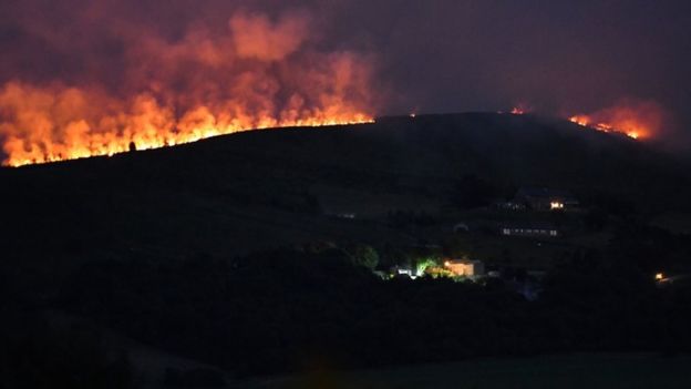
Harry Hayfield wrote a new post, With Wales having boasted two days of being the hottest place in the UK, on the site The Weather of Wales (and other parts of the United Kingdom) 5 years, 9 months ago
Now comes the downside, grass fires. First, a major one, which is still happening in moorlands of Greater Manchester. Saddleworth Moor (which lends its name to the Oldham East and Saddleworth constituency) has […]
-
What are the major causes of these fires? I am sure the tinder is quite dry this time of year to help start the fires. Do you have very many lightning-induced fires? Or are they mostly human-caused, cigarettes, barbecues, kids horsing around, etc? My friend Marty’s next trip over here will, among other things, bring over a lightning detector. He got one for himself, and of course Ray already has one. With all the heat you are getting, I would think all that daytime heating would help generate some air-mass thunderstorms, unless you get stable marine breezes that would inhibit/stifle development. Thanks, Kevin
-
The main priority for Greater Manchester Fire and Rescue at the moment is to put the fires out. The investigation into the cause will not start until that has happened and will probably involve Greater Manchester Police as well as the fire service. It is also possible that Tameside council (the area of local government that covers that area) may be brought it to establish what management controls need to be brought in to prevent another fire of this magnitude.
I think it is more than likely to be human related, as this heat has been very dry heat (humidity levels have been very low over the last few weeks) however it will be for the police and fire service to determine whether this was malicious (arson) or just an accident (that the people who caused it feel ashamed about and don’t want to come forward to admit it)
-
Thanks Harry. Let me know what they find out as to the cause. How many days with lightning do you get there? I wouldn’t think very many. Marty got me a lightning detector that he will bring over to me next time he visits. Ray already has one and he likes it. You probably don’t get enough lightning to make it worth it. Thanks
-
-
That’s a very good question actually as I cannot find any actual recorded data. All I know is that in the seven years we lived at our own house I can genuinely only recall one thunderstorm (and that was in October 2014)
-
-
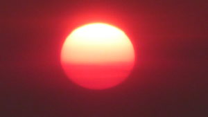
Harry Hayfield wrote a new post, Gobbledygook is the last thing we need during a heatwave, on the site The Weather of Wales (and other parts of the United Kingdom) 5 years, 10 months ago
The Misadventures of Gobbledegook the Turkey
Dictionary.com defines “Gobbledygook” as:
language that is meaningless or is made unintelligible by excessive use of technical terms.And it is my belief that […]
-
Over in the US a heat wave is defined by three straight days of excessive heat, usually considered to be 90 F (32 C) or greater. With global warming causing hotter summers the past several years, this threshold had less meaning, and should be extended to 5 straight days, IMHO. In DC, the normal average high in July is now about 89 F, so we can “normally” be in a heat wave almost more often than not. I pull for high temps of 80 F or less, and also cloudy days to help keep the temperature down. Some of the TV forecasters here locally in the DC area are calling for the next 10 days or longer possibly to have max temps of 90 or greater. I sure hope they are wrong. And more often than not, when the temp reaches 90 the dew point temp is often at 70 or more most of the time. We can get nighttime min air temps well up in the 70s (35 C) and occasionally at or a bit above 80 which is totally miserable. Often the dew point can be a good indicator of how low/high the overnight min will be. Ray tells me that the dew point temp at 3 PM can oftentimes help predict what the overnight min temps will be. Fronts, clouds, winds can put the “kabosh” on these predictions, however. Thanks for posting about these fires! We sure have our share of fires over much of the US, and “dry lightning” out west can really cause a major outbreak. Cheerio, Kevin
-
As I said in my post the current British definition is so complicated it might as well not exist. My personal feelings are that a heatwave should be defined as “at least 48 hours where the maximum temperature is 20% higher than average during the day”. For instance, the average temperature in the UK at this time of year is a maximum of 18°C (64°F) and a minimum of 8°C (48°F). Under my suggestion as soon as the daytime highs reach 22°C (72°F) a sliding scale of heatwave alerts is triggered. Level 1: 22°C – 25°C, Level 2: 25°C – 29°C, Level 3: 29°C – 32°C, Level 4: 32°C or more. Each level has a response based on local circumstances, so for instance a Level 1 alert would see care services speak to older people about how to keep cool where as a Level 4 alert would see that area of the country essentially shut down.
-
-
Harry Hayfield wrote a new post, The British Summer gets a boost, on the site The Weather of Wales (and other parts of the United Kingdom) 5 years, 10 months ago
The more observant of you will have noticed that the British weather of late has been lacking in action. Indeed, aside from storm Hector (as the Irish called it) since about the beginning of May it’s been so […]

-
Thanks for your excellent post, Harry on your recent (lack of significant) weather and that you will be using your new thermometer for charting upcoming daily variations (or lack thereof) in your climate. It will be interesting to see how well your new thermometer performs. Have you been able to find a hook or nail to hang the thermometer from? I gave Ray your email – he is also limited in funds and space at his apartment so he has a real appreciation of that. I didn’t talk to him on Saturday. Our wet patterns at the same time of your Omega block dryness of May and June (so far) are logical – we were on the other side of the Omega block with warm, moist air coming in on SE winds off the ocean. Late this week upcoming it looks like a mini-heat wave to finish out the month of June, with high temps into the mid 90s (around 35° C) by the end of the week. Ray’s and my friend Marty has been reporting temps increasingly more frequently in metric units. Other units of measurement will be changing over later. I am at a stage where I still have to convert, I cannot “think” metric if you know what I mean.
Thanks again and have a great rest of the weekend!
Kevin
-
-
Harry Hayfield commented on the post, It's been so quiet across the UK of late, it's been boring, on the site The Weather of Wales (and other parts of the United Kingdom) 5 years, 10 months ago
Thank you very much for that. I will admit I am surprised that the instruction drilled into us as children “Always face a thermometer on a north facing surface” has been dumped, presumably of course if you have a Stevenson screen that doesn’t really come into it.
As you know my broadband at the moment doesn’t like pictures so I can’t show you…[Read more]
-
Harry Hayfield commented on the post, It's been so quiet across the UK of late, it's been boring, on the site The Weather of Wales (and other parts of the United Kingdom) 5 years, 10 months ago
The thermometer is going to be hung in an alleyway that the house has (which is in shade 24/7) and therefore will record the actual temperature, however I cannot remember what height it needs to be. As I have said the rain guage in a place where nothing can drip into it and the wind guage (which needs a new battery already) will be hand held at…[Read more]
- Load More
Harry, that’s a pretty dramatic lighthouse picture. Your weather looks about as bad as ours.
Greetings Harry! Thanks for your post. I sure have missed hearing from you about your daily station data and/or monthly summary for August. Are you having problems? I have had problems of late myself, with my station down most of the time the past week so I have not posted during that time till a brief report this past Tuesday the 18th. My friend Marty came over on Tuesday and installed a new VP2 circuit board and now so far I have been up and running ever since. Perhaps you are still having periodic internet connection issues as Nathan mentioned to me a few weeks ago.
We recently endured quite a stormy spell here on much of the coast of the Eastern United States, particularly in the Carolinas from tropical system FLORENCE. As the remnant storm system was moving away from our area and out into the Atlantic I heard of forecasts of it maintaining some sort of circulation over the North Atlantic and possibly paying a visit to the British Isles. Have you heard any discussions of this on your side of the Big Pond? I always find it fascinating to follow those tropical systems from the United States area that make it to Europe in some form or other.
Take care and hope to hear more from you soon,
Kevin