


Daily Weather Reports
Air Quality Alert And Unreasonably Hot Temperatures . . . . .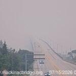
Today will not be a good day to be outdoors. Not only because it is hot, but we are under attack from Canadian wildfires once again. It seems like this is becoming an annual event. My picture was taken at the Mackinaw Bridge this morning, and the smoke is so... read more ❯
More Heat On The Way . . . .
Today is beginning with sun and comfortable temperatures, but the next week will bring the 90s back again. It isn't even enjoyable to be outdoors when it's that hot; that is unless you are on the water. I leave a bowl of water for any outdoor critters that need a... read more ❯
Pleasant Weather For Our Friday . . . . .
Our morning began with clouds, but now we have sun and partly cloudy skies. Temperatures are just warm enough and the humidity isn't too bad. Yesterday brought a shower during the early afternoon which left 0.12 in my rain gauge, and other storms missed us.
Our 2 PM temperature is 78°F,... read more ❯
Some Rain In Our Forecast . . . . .
We have showers and thunderstorms in the forecast but no severe weather is expected here. Temperatures are a little cooler, but the 90s are expected to come back by next weekend. So far today has been pleasant but rain is starting to show on the radar. We really don't need... read more ❯
Typical Michigan July Weather . . . . .
We have had a few days of comfortable weather, but now another hot day. Storms are expected tomorrow, then it should cool down a bit once again. Today is good for spending at the lake or water park.
Our 1PM temperature is 85°F, the humidity is 45%, and winds are from... read more ❯
A Respite From The Heat . . . .
I hope that everyone is having a good holiday weekend. The past two days have been stormy, which is not a good scenario for campers. Most have been high winds but no tornadoes. Highs have been in the upper 80s to lower 90s, with high humidity and dew points. We... read more ❯

Dangerous Heat Is Upon Us . . . .
It is like an oven outdoors and the only thing making it bearable is that we have a breeze. It doesn't help much when temperatures are in the 90s. In fact, some local forecasters are saying that some areas could reach 100°F. Also, there is always a chance for a... read more ❯
Major Heat Wave On The Way . . . .
We have some major heat heading our way for this week. We could see temps nearing 100F on some days, with the mid to upper 90s the on others. Definitely we'll see some records broken. There is an Extreme Heat Watch issued for our area from this Tuesday afternoon ... read more ❯
Rising Temperatures, Sunny Skies . . . .
It really feels like summer today, and a major heat wave is heading our way just in time for the holiday. It's the type of weather that you hope that the A/C doesn't quit on you. Today will still be quite comfortable, then by Monday, we'll be in the 90s... read more ❯