-
William Brantley wrote a new post on the site Jackson, TN's Climate Summary 7 years, 8 months ago
Lowest Barometric Pressure : 30.08″ at 6 p.m.
Highest Barometric Pressure : 30.17″ at 11 a.m., 12 p.m.Lowest Relative Humidity : 48% at 2 p.m.
Highest Relative Humidity : 96% at 2, 5, 6 a.m.Lowest Dew P […]

-

Kevin Shaw wrote a new post on the site West Rockville MD Weather 7 years, 8 months ago
Wednesday was mostly sunny with a few scattered cumulus at times in the afternoon, hot and humid like it has been over the past several days. The Wednesday maximum temperature was 90.3° as it was yesterday but @ […]

-

Karl Bonner wrote a new post on the site Karl's Weather Discussions 7 years, 8 months ago
The calendar has turned to September, and with it comes the end of summer – as least as weather geeks define it. Meteorological summer is defined as the entirety of June, July, and August in the northern […]
-
Karl Bonner wrote a new post on the site Karl Bonner's Weather Blog 7 years, 8 months ago
The calendar has turned to September, and with it comes the end of summer – as least as weather geeks define it. Meteorological summer is defined as the entirety of June, July, and August in the northern […]

-

Cathie Ursu wrote a new post on the site Mid Michigan Weather 7 years, 8 months ago
Today should be the last of this oppressive weather. A cold front will move through with more storms expected, then some decent weather will be a welcome relief. We should see highs only in the 70s for the re […]

-
Kevin Shaw wrote a new post on the site West Rockville MD Weather 7 years, 8 months ago
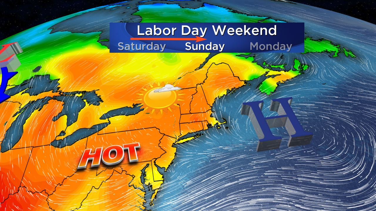
I have been busy with the Labor Day holiday and end of the month/beginning of the new month weather activities causing me not to be able to post my daily weather update the past few days. I will somewhat condense […]

-
William Brantley wrote a new post on the site Jackson, TN's Climate Summary 7 years, 8 months ago
Lowest Barometric Pressure : 30.08″ at 6, 7 p.m.
Highest Barometric Pressure : 30.21″ at 10, 11 a.m.Lowest Relative Humidity : 44% at 2 p.m.
Highest Relative Humidity : 94% at 2 a.m., 11 p.m. […] -
William Brantley wrote a new post on the site Jackson, TN's Climate Summary 7 years, 8 months ago
Lowest Barometric Pressure : 30.10″ at 6, 7 p.m.
Highest Barometric Pressure : 30.23″ at 10, 11 a.m.Lowest Relative Humidity : 47% at 5 p.m.
Highest Relative Humidity : 97% at 4 a.m.Lowest Dew Point […]
-
Cathie Ursu wrote a new post on the site Mid Michigan Weather 7 years, 8 months ago
Yesterday brought more heavy rain to the same areas that were affected by Tuesday’s storms. We sat out last night watching the lightning as it passed to our northwest. We did receive a little rain ov […]

-
Hi Cathie! Great post. Hope you had a great labor day. I noticed in the title line for this post the last word says “Michigag” instead of “Michigan”. You might want to fix that up. Just noticed it going through all the posts the past few days. Thanks for keeping us up on the latest weather updates in the Durand MI area. Kevin
-
-
William Brantley wrote a new post on the site Jackson, TN's Climate Summary 7 years, 8 months ago
Lowest Barometric Pressure : 30.05″ at 6 p.m.
Highest Barometric Pressure : 30.17″ at 9 a.m.Lowest Relative Humidity : 47% at 5 p.m.
Highest Relative Humidity : 97% at 6 a.m.Lowest Dew Point Tempe […]
-
Kevin Shaw wrote a new post on the site West Rockville MD Weather 7 years, 8 months ago
We had a mostly cloudy Saturday with high humidity once again and a late evening brief, heavy thunderstorm that got September started off to a wet start (0.86″ between 2045-2155 with a max rain rate of 3.58″/hour […]

-
Cathie Ursu wrote a new post on the site Mid Michigan Weather 7 years, 8 months ago
Yesterday was quite tranquil until late afternoon. We then began to see storms develop with even a tornado warning in the Jackson area. I haven’t heard of any damage or actual tornadoes however. We had a co […]
-
William Brantley wrote a new post on the site Jackson, TN's Climate Summary 7 years, 8 months ago
Lowest Barometric Pressure : 30.04″ at 3 a.m.
Highest Barometric Pressure : 30.17″ at 10, 11 a.m.Lowest Relative Humidity : 52% at 5 p.m.
Highest Relative Humidity : 93% at 6, 7 a.m.Lowest Dew Point […]
-
Kevin Shaw wrote a new post on the site West Rockville MD Weather 7 years, 8 months ago
A not so hot ending to the month of August, a mostly cloudy Friday with high humidity returning and occasional showers falling, mostly in the early AM hours (0.06″ between 0100-0200) and then a bit more in the […]

-

I’ve seen more flooding in Maryland. Anywhere close to Earth Networks or is it another area in Maryland?
-
Well a quick check of cocorahs (not possible to do earlier when the system was down) over Aug 31 to Sep 1 shows amounts for stations in Maryland listed on this website:
https://www.cocorahs.org/ViewData/TotalPrecipSummary.aspx
There are a handful of Montgomery County stations where I live and where Earth Networks is located, but there are no reporting stations within a few miles of Earth Networks Headquarters in Germantown. You will see station like mine at MD-MG-115 in West Rockville, and several fairly close by stations in Germantown, Gaithersburg and Rockville. The highest amount stations are in areas north and northeast of Baltimore with a few just to the south of that city. I saw a video of a flooded bridge in Harford County, which is a good 25-30 miles NE of Baltimore. Thanks for your question Nathan.
-
-
William Brantley wrote a new post on the site Jackson, TN's Climate Summary 7 years, 8 months ago
Lowest Barometric Pressure : 30.02″ at 5 – 7 p.m.
Highest Barometric Pressure : 30.11″ at 11 a.m.Lowest Relative Humidity : 55% at 4, 5 p.m.
Highest Relative Humidity : 100% at 7 a.m.Lowest Dew Point […]
-
Kevin Shaw wrote a new post on the site West Rockville MD Weather 7 years, 8 months ago
A partly cloudy Thursday was not as hot, failing to hit the 90° high temp mark for the first time since Monday, and was a bit less humid, with actual clear, blue skies in the morning and a dew point drop of about […]

-
William Brantley wrote a new post on the site Jackson, TN's Climate Summary 7 years, 8 months ago
Lowest Barometric Pressure : 30.02″ at 6 p.m.
Highest Barometric Pressure : 30.14″ at 9, 10 a.m.Lowest Relative Humidity : 55% at 5 p.m.
Highest Relative Humidity : 97% at 7 a.m.Lowest Dew Point Tempe […]
-
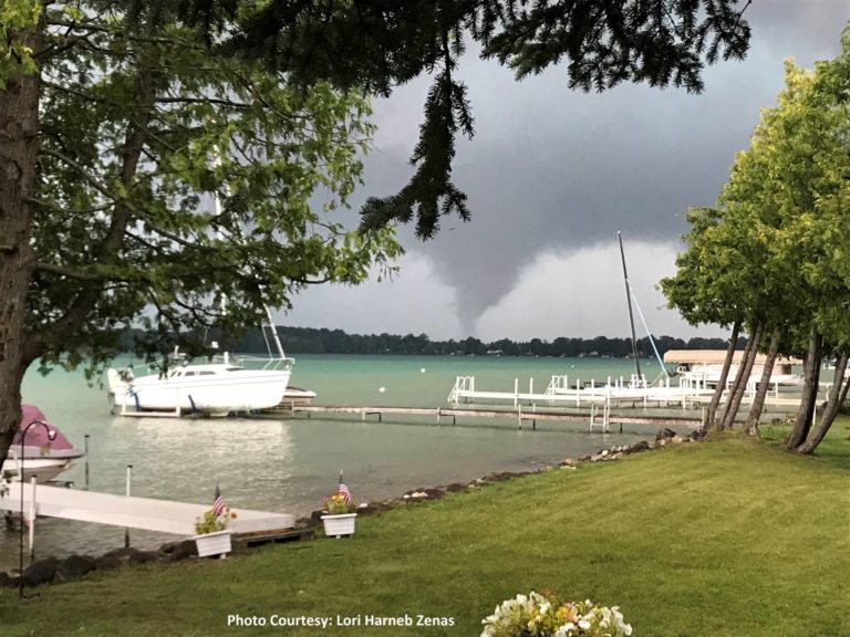
Cathie Ursu wrote a new post on the site Mid Michigan Weather 7 years, 8 months ago
Thousands are still without power in northern lower Michigan after severe storms moved through the state on Tuesday night. At least 4 tornadoes have been confirmed and much straight line wind damage in the […]
-
Thanks for the great report Cathie. I dug up some more information on the 4 confirmed tornadoes from the Gaylord MI NWS website. I didn’t see an F2 tornado in this report – 2 F0 and 2 F1 tornadoes and they didn’t use Lapeer that I could see. But they mentioned the same counties you did. Perhaps the F2 tornado you reported from Lapeer was evaluated for strength under further review after this NWS report, found at the following NWS website:
https://www.weather.gov/apx/severe-2018Aug28 -
Hi again Cathie. I double checked the location of Lapeer and found it considerably south of the Gaylord MI forecast office area of responsibility (AOR). It showed up in Google Maps east of Flint and within the Detroit/Pontiac NWS forecast office AOR. So I went to their page and unfortunately they apparently did not go out to Lapeer that I could see and check out this tornado and issue a report like the Gaylord office did. The NWS office out of Detroit/Pontiac does have a limited storm report for August 28, and it is at this website:
https://www.weather.gov/dtx/svrwx180828 -
I found out that the F2 tornado was just north east of West Branch. It wasn’t Lapeer.
-
Thanks Cathie. Makes more sense. I found West Branch on my Large Print Road Atlas. Looks like it is about 20-30 miles SE of Gaylord off of I-75. I just love travel and following routes with good maps. I was always the navigator on family trips while growing up.
-
-
-

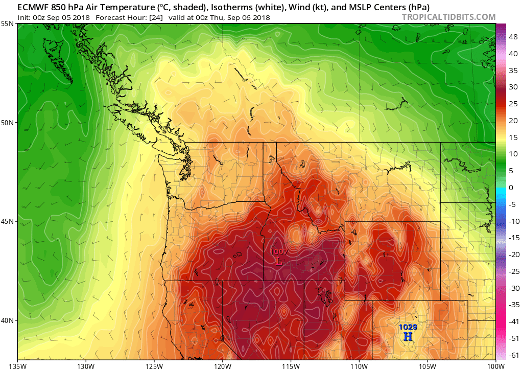
Jeff Taylor wrote a new post on the site Happy Valley, Oregon Weather 7 years, 8 months ago
FINAL UPDATE 9/10/2018:
With this morning’s 0.01″ rain measurement, falling between 5:00 and 6:00 A.M., the record-streak of consecutive days with no measurable precipitation has come to an […]

-
Kevin Shaw wrote a new post on the site West Rockville MD Weather 7 years, 8 months ago
A partly cloudy Wednesday was once again downright hot and humid, our third one of several this week this last week of August, with high temps reaching the lower 90s and dew points once again climbing through the […]

- Load More