-

Kevin Shaw wrote a new post on the site West Rockville MD Weather 8 years, 3 months ago
Saturday started out in the very early AM with clouds and light showers (0.08″ daily total, most fell between 0055-0210), then around sunrise very damp with light-moderate fog and mild, evolving into a partly […]

-

Harry Hayfield wrote a new post on the site The Weather of Wales (and other parts of the United Kingdom) 8 years, 3 months ago
The more observant of you will have noticed that the British weather of late has been lacking in action. Indeed, aside from storm Hector (as the Irish called it) since about the beginning of May it’s been so […]

-
Thanks for your excellent post, Harry on your recent (lack of significant) weather and that you will be using your new thermometer for charting upcoming daily variations (or lack thereof) in your climate. It will be interesting to see how well your new thermometer performs. Have you been able to find a hook or nail to hang the thermometer from? I gave Ray your email – he is also limited in funds and space at his apartment so he has a real appreciation of that. I didn’t talk to him on Saturday. Our wet patterns at the same time of your Omega block dryness of May and June (so far) are logical – we were on the other side of the Omega block with warm, moist air coming in on SE winds off the ocean. Late this week upcoming it looks like a mini-heat wave to finish out the month of June, with high temps into the mid 90s (around 35° C) by the end of the week. Ray’s and my friend Marty has been reporting temps increasingly more frequently in metric units. Other units of measurement will be changing over later. I am at a stage where I still have to convert, I cannot “think” metric if you know what I mean.
Thanks again and have a great rest of the weekend!
Kevin
-
-
William Brantley wrote a new post on the site Jackson, TN's Climate Summary 8 years, 3 months ago
Here is Saturday – June 23, 2018`s – Historical Climate Summary !
Lowest Barometric Pressure : 29.77″ at 3 a.m.
Highest Barometric Pressure : 29.87″ at 1 p.m.Lowest Relative Humidity : 59% at 5 p.m. […]

-
Kevin Shaw wrote a new post on the site West Rockville MD Weather 8 years, 3 months ago
Friday was a cloudy, cooler, wet day with persistent light showers (0.22″) off and on most of the day. Temperatures held mostly in the 60s all day after initial low 70s in the very early AM. Overnight into […]

-
William Brantley wrote a new post on the site Jackson, TN's Climate Summary 8 years, 3 months ago
Here is Friday – June 22, 2018`s – Historical Climate Summary !
Lowest Barometric Pressure : 29.75″ at 3 a.m., 6 p.m.
Highest Barometric Pressure : 29.80″ at 11:59 p.m.Lowest Relative Humidity : 55% at 3 […]
-
Kevin Shaw wrote a new post on the site West Rockville MD Weather 8 years, 3 months ago
On May 27, 2018, training thunderstorms severely affected the Ellicott City area with torrential downpours over a short period of time, causing the historic downtown area to flood severely. Main Street turned into […]

-
Kevin Shaw wrote a new post on the site West Rockville MD Weather 8 years, 3 months ago
Spreadsheet data file for May 2018:
2018-05-Rockville-2.8-WNW
MAY 2018 MONTHLY SUMMARY ROCKVILLE 2.8 WNW MARYLAND
By Kevin Shaw, Observer in ChargeMay 2018 featured significantly above normal rainfall […]

-
Kevin Shaw wrote a new post on the site West Rockville MD Weather 8 years, 3 months ago
Thursday was mostly cloudy, a tad cooler but still muggy, with a light AM shower between 1040 and 1105 (0.05″). Temperatures held mostly in the 70s all day. Overnight into Friday skies were cloudy, with temps only […]

-
William Brantley wrote a new post on the site Jackson, TN's Climate Summary 8 years, 3 months ago
Lowest Barometric Pressure : 29.75″ at 5 p.m.
Highest Barometric Pressure : 29.92″ at 12 a.m.Lowest Relative Humidity : 59% at 3 p.m.
Highest Relative Humidity : 100% at 4, 6 – 8 a.m., 7, 11, 11:59 p.m. […] -
Kevin Shaw wrote a new post on the site West Rockville MD Weather 8 years, 3 months ago
Wednesday was partly cloudy, cooler and drier in the AM, but clouded over in the afternoon and light rain (daily total 0.31″) moved in during the evening (1935-2135), with a modest rain rate of 0.47″/hour @ 1957. […]

-
William Brantley wrote a new post on the site Jackson, TN's Climate Summary 8 years, 3 months ago
Lowest Barometric Pressure : 29.89″ at 6, 7 p.m.
Highest Barometric Pressure : 30.00″ at 9, 11 a.m.Lowest Relative Humidity : 69% at 12 p.m.
Highest Relative Humidity : 100% at 11 p.m.Lowest Dew Point […]
-

Karl Bonner wrote a new post on the site Karl's Weather Discussions 8 years, 3 months ago
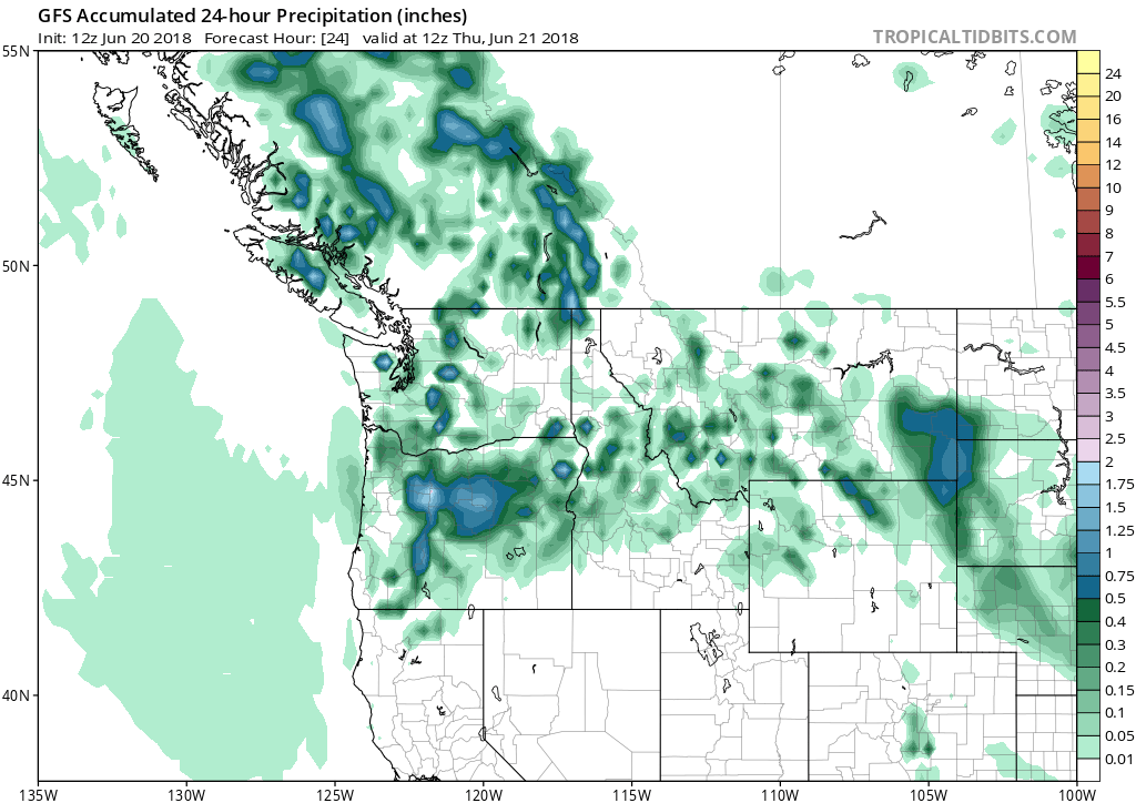
This is going to be real quick, but after a decent thunderstorm near The Dalles on Saturday and a big storm with outflow winds, for the Portland Metro on Sunday – today we’re going to have another good shot at […]
-
Karl Bonner wrote a new post on the site Karl Bonner's Weather Blog 8 years, 3 months ago
This is going to be real quick, but after a decent thunderstorm near The Dalles on Saturday and a big storm with outflow winds, for the Portland Metro on Sunday – today we’re going to have another good shot at […]

-
Kevin Shaw wrote a new post on the site West Rockville MD Weather 8 years, 3 months ago
Tuesday featured several changes throughout the day. The morning after sunrise was sunny and hot, as the high air and dew point temperatures for the day were reached a few minutes prior to noon. The afternoon […]

-
William Brantley wrote a new post on the site Jackson, TN's Climate Summary 8 years, 3 months ago
Lowest Barometric Pressure : 29.98″ at 6 – 9 p.m.
Highest Barometric Pressure : 30.11″ at 9 a.m.Lowest Relative Humidity : 47% at 2 p.m.
Highest Relative Humidity : 100% at 5 a.m.Lowest Dew Point Tempe […]
-

Cathie Ursu wrote a new post on the site Mid Michigan Weather 8 years, 3 months ago
It seems that the 90s are gone for a while and temperatures are back to where they should be. That’s a relief. I don’t do well at all when temps get much above 80°F. We received a few showers late yesterday whi […]

-
Kevin Shaw wrote a new post on the site West Rockville MD Weather 8 years, 3 months ago
Monday was a mostly to partly sunny, hazy, hot, humid day with clouds coming in during the later stages of the afternoon that put a lid on the increasing temperature. The clouds resulted from a line of storms […]

-
William Brantley wrote a new post on the site Jackson, TN's Climate Summary 8 years, 3 months ago
Here is Monday – June 18, 2018`s – Historical Climate Summary !
Lowest Barometric Pressure : 30.04″ at 7 p.m.
Highest Barometric Pressure : 30.17″ at 9, 10 a.m.Lowest Relative Humidity : 46% at 3 p.m. […]
-
Cathie Ursu wrote a new post on the site Mid Michigan Weather 8 years, 3 months ago
Yesterday was just too hot to even step outdoors with highs reaching 93°F. Fortunately, thunderstorms will be passing through later today and bringing cooler air with it. On the down side, there is a chance fo […]
-
Kevin Shaw wrote a new post on the site West Rockville MD Weather 8 years, 3 months ago
Sunday was a mostly sunny but hazier day with high clouds at times esp in the AM, and a warmer, more humid day. Temperatures started out around 70° in the early AM then rose just short of 90° by mid-afternoon. O […]

- Load More