-
William Brantley wrote a new post on the site Jackson, TN's Climate Summary 8 years, 2 months ago
Lowest Barometric Pressure : 29.87″ at 4 – 6 p.m.
Highest Barometric Pressure : 30.00″ at 9, 10 a.m.Lowest Relative Humidity : 46% at 3 p.m.
Highest Relative Humidity : 97% at 6 a.m.Lowest Dew Point Temp […]

-

Kevin Shaw wrote a new post on the site West Rockville MD Weather 8 years, 2 months ago
Saturday was a warmer, more humid, mostly cloudy/hazy day with temperatures starting out in the upper 60s in the early AM and rising into the mid 80s by mid-afternoon. Clouds dominated the skies, though the sun […]

-

Cathie Ursu wrote a new post on the site Mid Michigan Weather 8 years, 2 months ago
Today’s forecast called for a partly cloudy day, now that has changed. I’m really getting tired of rain and I hope that the entire summer isn’t like this. We received a total of 0.80″ from yesterday’s showers a […]

-

Karl Bonner wrote a new post on the site Karl's Weather Discussions 8 years, 2 months ago
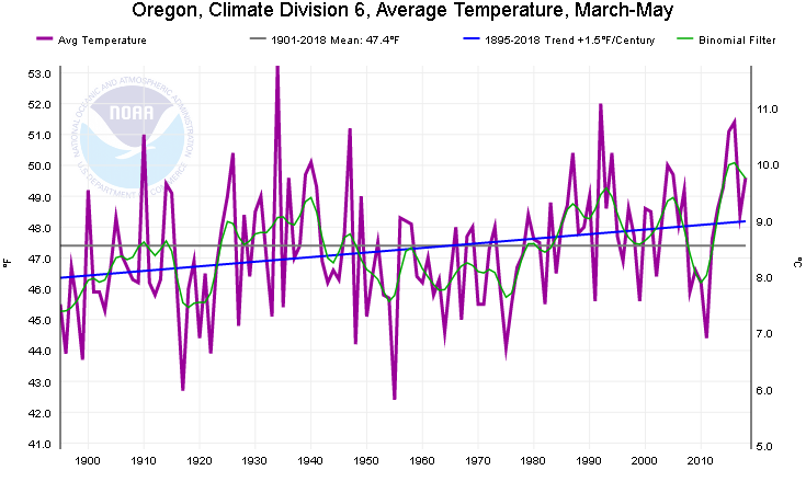
What a fun weather day for June! In the Portland Metro area there were heavy thunderstorms with dime-sized hail in places, and even reports of a minor tornado in East Vancouver. Here in The Dalles though, the big […]
-
Karl Bonner wrote a new post on the site Karl Bonner's Weather Blog 8 years, 2 months ago
What a fun weather day for June! In the Portland Metro area there were heavy thunderstorms with dime-sized hail in places, and even reports of a minor tornado in East Vancouver. Here in The Dalles though, the big […]

-

Awesome post Karl! A couple questions:
1.) Any idea why the springs have become so amplified as of late? Maybe it could be because we’ve had some pretty big El Nino/La Nina swings, and the Neutral years we’ve had have been quite variable. 2007-2008 and 2010-2011 were both very cool springs and were moderate/strong La Ninas… I remember this because I’m a skier and the ski season lasted a long time! The graph also shows 2009-2010 (which was an El Nino) having a cool spring, which is interesting.
The most anomalous years are actually usually weak ENSO or Neutral years (2014-2015 and 2016-2017 are great examples), and many of our recent Neutral years have been very anomalous indeed.
2.) How did you get the 98% for global warming? Seems like a good estimate (I’d go a little higher personally, like 99 or 99.5, but that’s just an off-the-cuff guess).
Also, it would be interesting to find the correlation coefficient between average March/May rainfall and temperature. This can be easily compiled manually by fetching data from NOAA’s NOW data and then putting it into Excel.
-
1. I’m guessing that springtime amplification may have something to do with the jet stream. Remember, one supposed side-effect of a rapidly warming climate, is that the jet can get bent out of its “normal” shape when the global temperature is steady. That would mean more pronounced cool and warm anomalies – at least relative to the decadal temperature trend. (Not the 30- or 100-year averages, of course!)
2. I’m just using the number 98% as a metaphor for “It’s pretty damn obvious that it’s gettin’ warmer!” I haven’t actually looked at the future simulations/distributions myself. But the data over the past half century is telling enough.
3. While I haven’t done any R-squared ops for temperature vs. precipitation, I DO know that a lot of super-cool springs haven’t been exceptionally wet. (Spring 2011 was an exception.) My guess is that you need the somewhat warmer, muggier airmasses of the central Pacific if you want really heavy rainfall in the spring. The deep cold troughs out of Western Canada are just a little too crisp to soak us. (Kind of like how really heavy fall rains can occur in a mild ‘Pineapple Express’ pattern)
-
-
Charlie Phillips wrote a new post on the site Charlie's Weather 8 years, 2 months ago
Our 4th day of storm chasing (5/31/2018) was a much-needed off day. After driving all the way from Albuquerque to the Texas Panhandle to catch some supercells on Memorial Day and seeing fantastic mesocyclones and […]

-

Hoping the days ahead bring more good weather for you! Mmmm, butter and eggs.
We had quite a variety of weather yesterday here in the Portland/Vancouver area. More rain than in the last 2 months and hail. I had hail up to 1/4” in the late morning, then possibly another round at noontime but I wasn’t home to observe it.
Snowing at Timberline this morning (4” as if 5 A.M.!).
-
-
William Brantley wrote a new post on the site Jackson, TN's Climate Summary 8 years, 2 months ago
Here is Saturday – June 9, 2018`s – Complete Climate Summary !
Lowest Barometric Pressure : 29.96″ at 7 p.m.
Highest Barometric Pressure : 30.11″ at 9, 10 a.m.Lowest Relative Humidity : 44% at 3 p.m […]
-
Kevin Shaw wrote a new post on the site West Rockville MD Weather 8 years, 2 months ago
Friday was a warmer and more humid, partly cloudy/hazy day with temperatures starting out in the lower 60s in the early AM and rising into the lower mid 80s by mid-afternoon. Fair weather cumulus dotted much of […]

-
Cathie Ursu wrote a new post on the site Mid Michigan Weather 8 years, 2 months ago
It was raining when I got up this morning and continues to do so. There was 0.31″ in my gauge at 9 AM, and it has rained continuously since then. I was going to finish planting my flowers but I guess that w […]

-
William Brantley wrote a new post on the site Jackson, TN's Climate Summary 8 years, 2 months ago
Here is Friday – June 8, 2018`s – Historical Climate Summary !
Lowest Barometric Pressure : 30.05″ at 3 a.m., 6, 7 p.m.
Highest Barometric Pressure : 30.14″ at 10 a.m.Lowest Relative Humidity : 40% at 5 p […]
-
Jeff Taylor wrote a new post on the site Maryland Climate and Weather 8 years, 2 months ago
May of 2018 was the wettest ever recorded for Maryland as the Statewide average of 7.68” surpassed the previous record of 7.31”. The month actually started off quite dry through most of the first half (except for […]

-
Great summary Jeff! I have been really busy with all sorts of activities, including getting used to my new rollator walker I got with Marty’s help a week ago. I hope to get all the revision edits together and post the Ellicott City floods on WT sometime this weekend. Will you be able to then slightly modify your May Maryland report to refer to my WT article after publication ? BTW, I was surprised by the 53″ of cover at Timberline the other day – they certainly have a better place to measure the snow than the parking lot – where I saw a mostly snow-free parking lot (not just the paved, plowed part).
-
Thanks, Kevin! Absolutely, I’ll link to your summary of the Ellicott City article, Kevin. Just let me know when you’ve posted it and I’ll grab the web link.
-
Thanks for posting the link to my article on the Ellicott City flooding. I hope to add to it sometime as more information comes in and I get a chance to.
-
-
Kevin Shaw wrote a new post on the site West Rockville MD Weather 8 years, 2 months ago
Thursday was another pleasant, partly cloudy day with comfortable temperatures and dew points. Temperatures started out in the upper 50s in the early AM and rose into the upper 70s by mid-afternoon. Fair weather […]

-
Cathie Ursu wrote a new post on the site Mid Michigan Weather 8 years, 2 months ago
Wow! It’s hard to believe that the longest day of the year is just two weeks away. This year is flying by and the fact that winter didn’t end for us until mid April is probably the reason. This is the la […]

-
William Brantley wrote a new post on the site Jackson, TN's Climate Summary 8 years, 2 months ago
Here is Thursday – June 7, 2018`s – Historical Climate Summary !
Lowest Barometric Pressure : 29.95″ at 2 a.m.
Highest Barometric Pressure : 30.06″ at 9 a.m. – 12 p.m., 11, 11:59 p.m.Lowest Relative Hum […]
-
Cathie Ursu wrote a new post on the site Mid Michigan Weather 8 years, 2 months ago
This morning is perfect with plenty of sun and a light breeze. Highs should reach near 80°F. Unfortunately, we have more rain coming for the weekend, something we don’t need. We’ve been mowing the lawn ab […]

-
Kevin Shaw wrote a new post on the site West Rockville MD Weather 8 years, 2 months ago
Wednesday was a pleasant, partly cloudy day with comfortable temperatures and dew points. Temperatures started out in the upper 50s in the early AM and rose into the mid 70s by mid-afternoon. Overnight into […]

-
William Brantley wrote a new post on the site Jackson, TN's Climate Summary 8 years, 2 months ago
Here is Wednesday – June 6, 2018`s – Historical Climate Summary !
Lowest Barometric Pressure : 29.88″ at 2, 3 a.m.
Highest Barometric Pressure : 29.97″ at 10, 11 a.m.Lowest Relative Humidity : 38% at 2 p […]
-
Jeff Taylor wrote a new post on the site Happy Valley, Oregon Weather 8 years, 2 months ago
TEMPERATURES
It was one of the warmest months of May with Mean Temperatures running nearly +5° departures from Normals. It was a rollercoaster of temperatures through the month, starting off chilly (May’s Low […]

-
Thanks Jeff. Looks like Mt Hood is wearing its hat today! Snow level still looks pretty low – I guess there is patchy cover at Timberline Lodge now after your warm month. Is it the resolution of the photo, my computer, or was it hazy on this day of the picture? I don’t think you all have started your fire season yet. Here in Maryland we are nice and wet to keep the fires at a minimum. The rest of the summer – we shall see…
-
Hi Kevin. It was a bit of a hazy day when I took that pic of Hood.
This morning’s report from Timberline shows the morning snow depth was 53”.
After very little precip here since mid-April, models are showing a fairly robust system (especially for June here) moving in on Friday, showing our area getting 0.50”-1.00”! Snow levels are expected to drop to about the 4000’ level so Timberline could get quite a dumping.
-
-
Cathie Ursu wrote a new post on the site Mid Michigan Weather 8 years, 2 months ago
Temperatures are cool this morning but the sun is shining brightly and very little wind for a change. Radar is showing no precip anywhere in the state and highs should be just about where they should be for […]
-
Kevin Shaw wrote a new post on the site West Rockville MD Weather 8 years, 2 months ago
Tuesday started out clear/sunny and cool. Increasing clouds in the afternoon yielded to threateningly cloudy skies in the evening, as a cold front rushed through from the north. Storms nearer the PA border were […]

- Load More