-

Kevin Shaw wrote a new post on the site West Rockville MD Weather 8 years, 10 months ago
Wednesday was a cloudy, cooler, occasionally rainy day (0.50″), particularly late in the evening when most of the daily rain fell, peaking at a rain rate of 3.37″/hour at 2338 EDT. Temperatures stayed in the low […]
-

Leon Dabbs wrote a new post on the site Leon,s Backyard WX Report 8 years, 10 months ago
***North winds possible Thursday night through Friday night***
***Offshore winds and warmer temperatures this weekend***
The cooling trend that began yesterday will continue through Thursday as temperatures […]

-

Cathie Ursu wrote a new post on the site Mid Michigan Weather 8 years, 10 months ago
Our Wednesday morning is beginning with light to moderate rain showers. I emptied 0.54″ from my gauge at 8 AM this morning and it has been raining ever since. It appears that this will last most of the day […]

-
Kevin Shaw wrote a new post on the site West Rockville MD Weather 8 years, 10 months ago
Tuesday was partly cloudy, still quite warm and a bit less humid, with no rain around today. Temperatures rose from the mid 60s in the early AM to the muggy low 80s in the afternoon among the partly cloudy skies. […]

-
Kevin Shaw wrote a new post on the site West Rockville MD Weather 8 years, 10 months ago
Tuesday was partly cloudy, still quite warm and a bit less humid, with no rain around today. Temperatures rose from the mid 60s in the early AM to the muggy low 80s in the afternoon among the partly cloudy skies. […]
-

Charlie Phillips wrote a new post on the site Charlie's Weather 8 years, 10 months ago
We got a taste of winter in mid-September, when an unseasonably cool upper-level trough dropped several inches of the white stuff to Timberline, Paradise Ranger Station, and many other locations in the Cascades […]

-
Great post Charlie! Great weather up there in the Pac NW mountains now. Can’t wait to see how big a dump key places get. I have a friend who has been doing extensive traveling with his lovely wife and just passed through Crater Lake. He was fascinated by the long term snowfall record at the COOP station at Park HQ there. There has been a general trend downward through the 20th century and into the 21st He has a theory to explain this drop, and it isn’t due to global warming. Fascinating! Thanks for this great post Charlie!
-
Thanks Kevin! Yup, tons of snowfall for this early in the season. Timberline at Mt. Hood even opened a chair for one day!
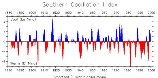
I’d like to hear his theory! I believe there’s been a general downward trend throughout the Washington Cascades as well. I wonder if El Nino/La Nina play a role… there were far more La Ninas (good for snow here) in the 1950s-1970s and there were far fewer to end the 20th century.
-
Thanks Charlie. My friend is still driving out west with his wife so he won’t be able to shed any light about his theory on the decline of Pac NW snowfall (Particularly focus of study are the Crater Lake OR long time snow records). One thing I have been looking for over the past few years are Pac NW climate records for January 1950. As I understand it, it was a really cold and snowy month. NWS/NCEI doesn’t have any records for the month for Washington State sights, and I believe Oregon as well. The limited amount of data I have seen of low, normally milder spots like Portland and Seattle even had several very cold days and significant snows. Meanwhile here in Maryland and through much of the Eastern US we had a record warm month, with temps reaching 80 on a few days near the end of the month at many sites. Must have been quite an amplified pattern of trough in the NW and ridge over parts of the Eastern US. Fascinating!
Stay well Charlie,
Kevin
-
-
Kevin Shaw wrote a new post on the site West Rockville MD Weather 8 years, 10 months ago
Monday was mostly cloudy, quite warm and humid, with morning steady light rain (0.56″) from dying tropical storm Nate with dew point temperatures mostly in the 70s all day. Temperatures rose from the muggy low 70 […]

-
Kevin Shaw wrote a new post on the site West Rockville MD Weather 8 years, 10 months ago
Monday was mostly cloudy, quite warm and humid, with morning steady light rain (0.56″) from dying tropical storm Nate with dew point temperatures mostly in the 70s all day. Temperatures rose from the muggy low 70s […]
-
William Brantley wrote a new post on the site Jackson, TN's Climate Summary 8 years, 10 months ago
Here`s Jackson & West TN`s Climate Summary & Forecast !
-
Kevin Shaw wrote a new post on the site West Rockville MD Weather 8 years, 10 months ago
Sunday was mostly cloudy, still warm, humid, with finally some rain (0.13″ through midnight) with dew point temperatures staying over the 70° mark all day. Temperatures stayed in the 70s all day. Dew points did […]

-
Kevin Shaw wrote a new post on the site West Rockville MD Weather 8 years, 10 months ago
Sunday was mostly cloudy, still warm, humid, with finally some rain (0.13″ through midnight) with dew point temperatures staying over the 70° mark all day. Temperatures stayed in the 70s all day. Dew points did […]
-
William Brantley wrote a new post on the site Jackson, TN's Climate Summary 8 years, 10 months ago
Here`s Jackson & West TN`s Climate Summary & Forecast !
-
Cathie Ursu wrote a new post on the site Mid Michigan Weather 8 years, 10 months ago
We have been under drought conditions over the past month, and the past few days have put a dent in it. Rain amounts on Thursday, Friday, and yesterday have totaled just under an inch in my area and it was b […]

-
Kevin Shaw wrote a new post on the site West Rockville MD Weather 8 years, 10 months ago
Remember now you can get the ground-based VP2 data on Weatherlink. You can access the data through http://www.weatherlink.com/user/walrusman444. I am also now on weather underground. My ID is K […]
-
Kevin Shaw wrote a new post on the site West Rockville MD Weather 8 years, 10 months ago
Saturday was a partly to mostly cloudy, warm, dry day with a rise in dew point temperatures over the 70° mark after a mild early AM. Temperatures rose from an early AM low around 60° to the 80° mark in the mi […]
-
William Brantley wrote a new post on the site Jackson, TN's Climate Summary 8 years, 10 months ago
Here`s Jackson & West TN`s Climate Summary & Forecast for Saturday – October 7, 2017 !
-
Charlie Phillips wrote a new post on the site Charlie's Weather 8 years, 10 months ago
Now that we are officially in autumn, I can hardly contain my excitement for storm season to get underway. Our transition from autumn into winter is fast and furious; in only 1 1/2 months, we’ll be in the […]

-

Very interesting article, Charlie! Thanks for investigating. Of all of the effects you mention, the snow/ice cover are what stand out to me as the major influence (first Autumn snow cover quickly initiating a drop in temps, resulting in more snow, etc., then the max snow cover taking a long time to fully melt delays Spring warming).
I’m hoping for some lowland snows this winter too! Time to pull out and clean my snowboard.
-
-
Cathie Ursu wrote a new post on the site Mid Michigan Weather 8 years, 10 months ago
We are finally getting some much needed rain. We received 0.27″ yesterday, and another 0.35″ overnight. Radar is showing that it is far from over and that’s good news, although today shouldn’t be a total w […]

-
Kevin Shaw wrote a new post on the site West Rockville MD Weather 8 years, 10 months ago
Friday was a partly cloudy, warm, dry day with a rise in dew point temperatures after a milder early AM. Temperatures rose from an early AM low 60s to the upper 70s in the mid-afternoon. Dew points remained […]
-
Kevin Shaw wrote a new post on the site West Rockville MD Weather 8 years, 10 months ago
Friday was a partly cloudy, warm, dry day with a rise in dew point temperatures after a milder early AM. Temperatures rose from an early AM low 60s to the upper 70s in the mid-afternoon. Dew points remained […]
- Load More