-

Charlie Phillips wrote a new post on the site Charlie's Weather 9 years, 5 months ago
Yesterday evening, while biking to work (I work night shifts at my weather job), I heard the first robin in many months!
The first chirp from a robin has traditionally been associated with the beginning of […]

-
Charlie started the topic Cool and Wet March in the forum Weather Talk 9 years, 5 months ago
Doesn’t look like we’ll warm up and dry out anytime soon. Latest GFS ensembles give us near-normal temperatures but well -above-normal precipitation in the extended.
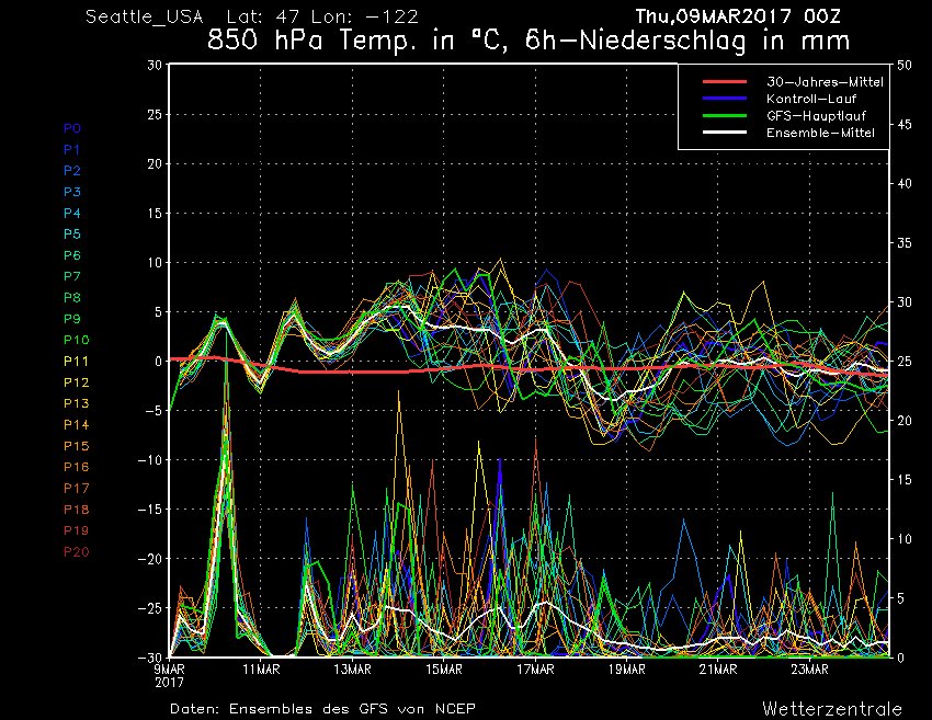
-
Charlie replied to the topic Visualizing Weather Data in the forum Projects 9 years, 5 months ago
Here’s the newest model chart I’ve been working on… this shows the 500 hPa heights and absolute vorticity over the NE Pacific. I added a function that finds the relative minima and maxima of heights and plots them, but I still have some work to do on implementing this function… namely, getting rid of extraneous minima and maxima over the…[Read more]
-
Charlie Phillips wrote a new post on the site Charlie's Weather 9 years, 5 months ago
On Friday, the Washington Post published an article concerning a memo drafted by the Office of Management and Budget for the 2018 fiscal year. This memo proposed drastic cuts to NOAA that would lead to a 18% […]

-

WONDERFUL post Charlie!!! I agree wholeheartedly with your “investment economics” view of weather services.
Of course, for the past 20-plus years Republican Party ideology has been dominated by the capitalism-always-good-government-always-bad mentality. Rather than seeing the two spheres as complementary to each other, as most trained economists do. There are things that central governments totally stink at doing, and there are some things where government blows the private competition away. The American public needs to understand this basic fact of economic science.
When it comes to weather forecasting…we have two real weak spots in the PNW. One is the lack of an Oregon coast radar. The other is the Columbia Basin winter inversion mechanism. Particularly for Portland, both of these come into play in potential snow/ice storms. The models kept trying to push the cold air out of the Columbia Basin during December through mid-February, but time and time again the stubborn low-level airmass and high pressure ran circles around the forecasts.
Better modeling of the relationship between sun angle, airmass temps and inversions east of the Cascades will go a long way toward improving our forecasting between October and March.
-
Hey Karl, thanks so much for the compliments! I’m not a trained economist, but my understanding of capitalism is that it works great when there is competition. When things turn anti-competitive, wealth inequality skyrockets, prices go up, and capitalism fails to function properly. That’s why government has the authority to break up monopolies.
We need something like the National Weather Service to provide “official” warnings people can trust. If the Weather Channel issues a tornado warning based on doppler radar signatures but Accuweather doesn’t, who are you going to trust? Competition doesn’t work here – it could cost lives.
What’s really frustrating is even the GOVERNMENT seems to be playing this “competition game” with our tax dollars. Just look at the Department of Defense… the Navy (NOGAPS) and Air Force (previously WRF, now UKMET) operated in separate spheres, with little collaboration. The NOGAPS is an inferior model compared to the GFS, and the fact that the Air Force ditched an American model for a British one is just plain depressing. These organizations are acting like private enterprises with trade secrets… the only difference is we are funding them in doing so. I could go on and on… there are way too many hurricane models, and I believe we should decommission the NAM. Bottom line: it makes far more sense to have one excellent model than a than a few good ones and a ton of mediocre ones.
At the Pacific Northwest Weather Workshop, Cliff Mass actually talked about the tendency for the WRF to overmix, especially in Portland during Columbia River Gorge outflow events. This was because like most models, the model layers of the WRF contour terrain, and the mixing in the model physics was occurring on these sloped layers, resulting in more vertical mixing. There was an option to have purely horizontal mixing in the WRF, but there was a bug in this and it didn’t run. It was FINALLY fixed earlier this winter, and when the UW implemented this feature, the tendency to overmix cool Gorge flow in the Portland Metro area was MUCH less. The current WRF from the UW now uses the horizontal mixing option.
-
Thanks Joel. Yes, climate change will bring an increase in the severity and/or frequency of many types of severe weather, particularly heat waves (and fires), hurricanes, floods, and droughts. Weather disasters cost the US tens of billions of dollars of damage each year… funds dedicated to better models, forecasts and subsequent preparation could pay off with a single storm!
-
Thanks Sara! And yeah, get those term papers done! 🙂
-
-
Charlie Phillips wrote a new post on the site Charlie's Weather 9 years, 5 months ago
Not many people know that March, on average, is nearly as snowy as February for most of the Cascades and Olympics. Snoqualmie Pass, for example, averages 72 inches for February vs 71.7 inches for March. Yes, March […]

-
Karl Bonner wrote a new post on the site Karl's Weather Discussions 9 years, 5 months ago
(more photos on the Facebook version of this post)
It’s that time of year again. Every year around the end of February / beginning of March I post all the signs of the coming spring in gardens and landscapes […]

-
Karl Bonner wrote a new post on the site Karl Bonner's Weather Blog 9 years, 5 months ago
(more photos on the Facebook version of this post)
It’s that time of year again. Every year around the end of February / beginning of March I post all the signs of the coming spring in gardens and landscapes […]
-
My brother lives in Walla Walla and is finishing his senior year there, and he says it’s been miserably cold this winter. And yeah, our flowers on our tulip tree are WAY behind schedule, especially compared to the past two years!
-
Check out my “Missing Blog Post” about the mid-March cold snap that wasn’t:
March 3 MISSING Blog Entry: What Could Have Been This Season…
Now THAT would have been a fun one to see become reality!
-
-
Charlie Phillips wrote a new post on the site Charlie's Weather 9 years, 5 months ago
Before I explain Seattle’s crazy weather on Monday, I must apologize for not keeping you updated on the situation throughout the day and night! Since I’ve moved down to Portland, I’ve definitely been more […]

-
Christopher Scragg wrote a new post on the site Phoenix Weather Blog 9 years, 5 months ago
For a weather nerd; lightning, thunder and hail is a great way to start the day! Clouds began bubbling around 9AM and quickly led to towering thunderstorms across the Valley. The huge storms came as a surprise […]

-
Awesome stuff! There are thunderstorms all over the country right now… Seattle had thundersnow (check out the video of lightning striking the Space Needle!) and there are some tornadic storms rolling through the Midwest this evening.
Really like the timelapse too… that’s very cool.
-
-
Karl Bonner wrote a new post on the site Karl's Weather Discussions 9 years, 5 months ago
The last two days have been a classic case of “Late Winter Slop” in the Pacific Northwest. There has been a lot of snow in the Coast Range, Cascade foothills and High Cascades – and even low elevations have seen […]

-
Karl Bonner wrote a new post on the site Karl Bonner's Weather Blog 9 years, 5 months ago
The last two days have been a classic case of “Late Winter Slop” in the Pacific Northwest. There has been a lot of snow in the Coast Range, Cascade foothills and High Cascades – and even low elevations have seen […]
-
Charlie Phillips wrote a new post on the site Charlie's Weather 9 years, 5 months ago
Folks in the Seattle metro were treated to some snow this morning as a convergence zone formed over the area! This zone was hinted at by last night’s high-resolution UW WRF-GFS, but the timing was off – the […]

-
Charlie Phillips wrote a new post on the site Charlie's Weather 9 years, 5 months ago
My personal “line in the sand” past which lowland snow events become more and more unlikely is Valentine’s Day. After Valentine’s Day, longer days and higher sun angles make cold temperatures at the surface much […]

-
Charlie replied to the topic Visualizing Weather Data in the forum Projects 9 years, 5 months ago
We finally have something on GitHub!
https://github.com/WeatherTogether/model-charts/blob/master/500mbvort.gs
This is a model chart showing the absolute vorticity and geopotential height at 500 mb from the GFS model. I love this chart for getting an idea of the general flow throughout the atmosphere… there’s a reason this was the first chart I…[Read more]
-
Charlie replied to the topic Heavy Squalls Around Pacific Northwest in the forum Weather Talk 9 years, 5 months ago
Different week, more squalls, this time with graupel. I think we’ll have a lot of this over the next few days, particularly Friday as an upper-level low approaches. The upper atmosphere is very cool and higher sun angles will allow for more substantial daytime heating and the formation of convective showers.
Graupel forms when supercooled water…[Read more]
-
Karl Bonner wrote a new post on the site Karl's Weather Discussions 9 years, 5 months ago
(This was posted on my Facebook notes 2 days ago.)
We’re fast approaching that moment I truly dread – the moment when I have to decide that The Dalles is no longer under “continuous snow cover.” I’m not an […]
-
Karl Bonner wrote a new post on the site Karl Bonner's Weather Blog 9 years, 5 months ago
(This was posted on my Facebook notes 2 days ago.)
We’re fast approaching that moment I truly dread – the moment when I have to decide that The Dalles is no longer under “continuous snow cover.” I’m not an […] -
Charlie replied to the topic Oroville Dam Spillway Updates in the forum Weather Talk 9 years, 5 months ago
Even though they are still releasing a ton of water down the eroded spillway, Lake Oroville is now at 80% capacity (up from 79% yesterday) due to heavy rains throughout Northern California. Upstream reservoirs are also continuing to rise as water is withheld behind the dams… Antelope Lake is now at 110% capacity!
Though the extended still looks…[Read more]
-
Charlie started the topic Oroville Dam Photos in the forum Weather Photography 9 years, 5 months ago
These aren’t my photos, but they are so good I had to share. The California Department of Water Resources has a great album of images from the Oroville Dam.
-
Charlie started the topic Oroville Dam Spillway Updates in the forum Weather Talk 9 years, 5 months ago
This has been such a huge weather-related event, I don’t know why I’m just mentioning it now! I have a feeling that Oroville Dam will be in the news for much of this spring as runoff from the snowpack in the Sierras flows into Lake Oroville.
Here’s a recent blog of mine, and here’s a link to some incredible pictures taken by the California…[Read more]
- Load More



It has been a long winter… in fact, it has been the coldest winter in a generation! Check out Cliff’s latest blog on it.
http://cliffmass.blogspot.com/2017/03/the-coldest-winter-in-generation-for.html