

@charliep127
Active 5 hours, 38 minutes ago-

Charlie Phillips commented on the post, Early November: Winter's First Little Tease?, on the site 8 years, 11 months ago
This really is a classic pattern for snow – I wish it was occurring just a few weeks later! At this point, I think The Dalles will see flakes while PDX will just get rain, or a rain-snow mix. Perhaps the West Hills could get something. Monday morning is still a LONG ways out though.
-
Charlie Phillips commented on the post, Arkansas Winter Outlook 2017-18, on the site 8 years, 11 months ago
Great first post Will! I love your explanation of the Arctic Oscillation – we always root for a negative phase here in the Pacific Northwest so the polar vortex can deliver a good arctic blast and hopefully a chance of snow.
-
Charlie Phillips commented on the post, Here`s My You Tube Weather Video for Monday – October 30, 2017 !, on the site 8 years, 11 months ago
Wow, 88 last year at this time!!! It’s definitely starting to feel a bit nippy here in Seattle… highs were in the lower 60s and the trees are slightly past their peak colors. Thanks as always for the detailed video and climate summary.
-
Charlie Phillips's profile was updated 8 years, 11 months ago
-
Charlie Phillips commented on the post, Halloween forecast for Reno, on the site 8 years, 11 months ago
That Sierra snowfal map looks spooky… in a very good way!!! Hopefully it’s a precursor of things to come as far as mountain snow is concerned.
-
Charlie Phillips wrote a new post on the site Charlie's Weather 8 years, 11 months ago
With a strong atmospheric river underway, I thought I’d take some time to delve a little deeper into these phenomena. In this blog, I’ll cover the basic characteristics of an atmospheric river, how these […]

-
Charlie Phillips wrote a new post on the site Charlie's Weather 8 years, 11 months ago
Today was just a prelude to the stormy weekend ahead, but that doesn’t mean it wasn’t exciting! A cool and unstable air mass poured into the region, bringing brief but heavy showers to the lowlands and heavy snow […]

-
Charlie Phillips wrote a new post on the site Charlie's Weather 8 years, 11 months ago
Our first respectable storm of the season drenched Western Washington and Oregon with heavy rain on Wednesday and Thursday, bringing an inch of rain to many places in the lowlands and several inches in the […]

-
Charlie Phillips commented on the post, Storm Season Begins This Week, on the site 8 years, 11 months ago
I love the rain… it was great to hear it last night while falling asleep. Rainfall totals are looking very impressive for the weekend… latest WRF gives us between 2.5 and 5 inches in 48 hours, with the potential for more than 10 inches by Mt. Hood.
-
Charlie Phillips wrote a new post on the site Charlie's Weather 8 years, 11 months ago
One of my recent posts talked about how the transition to winter is quicker than the transition to spring. Though the post was concerned with temperature changes and had a global perspective, we in the Pacific […]

-

Looking forward to getting some real weather as we move into the stormy season! I bought these rain gauges for a reason 😉
-
I love the rain… it was great to hear it last night while falling asleep. Rainfall totals are looking very impressive for the weekend… latest WRF gives us between 2.5 and 5 inches in 48 hours, with the potential for more than 10 inches by Mt. Hood.
-
-
Charlie Phillips commented on the post, First Snow of the Season for the Lower Passes, on the site 8 years, 11 months ago
Thanks Kevin! Yup, tons of snowfall for this early in the season. Timberline at Mt. Hood even opened a chair for one day!
I’d like to hear his theory! I believe there’s been a general downward trend throughout the Washington Cascades as well. I wonder if El Nino/La Nina play a role… there were far more La Ninas (good for snow here) in the…[Read more]
-
Charlie Phillips commented on the post, The Drought is Over – Mid Michigan, on the site 8 years, 11 months ago
Wow, that’s a ton of rain! Sounds like it’s pretty active over there right now.
-
Charlie Phillips wrote a new post on the site Charlie's Weather 8 years, 11 months ago
We got a taste of winter in mid-September, when an unseasonably cool upper-level trough dropped several inches of the white stuff to Timberline, Paradise Ranger Station, and many other locations in the Cascades […]

-

Great post Charlie! Great weather up there in the Pac NW mountains now. Can’t wait to see how big a dump key places get. I have a friend who has been doing extensive traveling with his lovely wife and just passed through Crater Lake. He was fascinated by the long term snowfall record at the COOP station at Park HQ there. There has been a general trend downward through the 20th century and into the 21st He has a theory to explain this drop, and it isn’t due to global warming. Fascinating! Thanks for this great post Charlie!
-
Thanks Kevin! Yup, tons of snowfall for this early in the season. Timberline at Mt. Hood even opened a chair for one day!
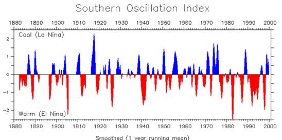
I’d like to hear his theory! I believe there’s been a general downward trend throughout the Washington Cascades as well. I wonder if El Nino/La Nina play a role… there were far more La Ninas (good for snow here) in the 1950s-1970s and there were far fewer to end the 20th century.
-
Thanks Charlie. My friend is still driving out west with his wife so he won’t be able to shed any light about his theory on the decline of Pac NW snowfall (Particularly focus of study are the Crater Lake OR long time snow records). One thing I have been looking for over the past few years are Pac NW climate records for January 1950. As I understand it, it was a really cold and snowy month. NWS/NCEI doesn’t have any records for the month for Washington State sights, and I believe Oregon as well. The limited amount of data I have seen of low, normally milder spots like Portland and Seattle even had several very cold days and significant snows. Meanwhile here in Maryland and through much of the Eastern US we had a record warm month, with temps reaching 80 on a few days near the end of the month at many sites. Must have been quite an amplified pattern of trough in the NW and ridge over parts of the Eastern US. Fascinating!
Stay well Charlie,
Kevin
-
-
Charlie Phillips wrote a new post on the site Charlie's Weather 8 years, 12 months ago
Now that we are officially in autumn, I can hardly contain my excitement for storm season to get underway. Our transition from autumn into winter is fast and furious; in only 1 1/2 months, we’ll be in the […]

-
Very interesting article, Charlie! Thanks for investigating. Of all of the effects you mention, the snow/ice cover are what stand out to me as the major influence (first Autumn snow cover quickly initiating a drop in temps, resulting in more snow, etc., then the max snow cover taking a long time to fully melt delays Spring warming).
I’m hoping for some lowland snows this winter too! Time to pull out and clean my snowboard.
-
-
Charlie Phillips wrote a new post on the site Karl Bonner's Weather Blog 9 years ago
A lot has happened in the weather world since I blogged last, both locally and nationally. Normally I like to relax in September because the weather is too “beautifully boring” to write about at length. But […]

-
Charlie Phillips commented on the post, Do the Tri-Cities really get 300 days of sunshine a year?, on the site 9 years ago
That’s a pretty high compliment! Now all I need is a catchphrase. 🙂
-
Charlie Phillips wrote a new post on the site Charlie's Weather 9 years ago
FINALLY!
It’s one thing to be overjoyed at the first stormy forecast of autumn, but to actually see the moderate rain, gusty winds, and even the mountain snow associated with it is nothing short of wonderful. […]

-

Love your post and your enthusiam! Charlie, you are the Cisco Morris of PNW weather forecasts!
-
That’s a pretty high compliment! Now all I need is a catchphrase. 🙂
-
-
Charlie Phillips commented on the post, Baltimore Top-10 Warmest & Coldest Months and Years – Mean Temperatures, on the site 9 years ago
Good morning cloudy and mild Walrus! 🙂
-
Charlie Phillips commented on the post, Winter's first snowfall… in summer., on the site 9 years ago
I’m impressed that you wrote this from your phone! I have trouble texting from my phone :p
-
Charlie Phillips commented on the post, La Nina Watch Issued!, on the site 9 years ago
Patricia, you deal with MUCH harsher winters in Michigan than we do in Portland, so I completely understand! For us, La Ninas just mean 44 degrees and rainy instead of 45 degrees and rainy, and there’s nothing skiers love more than low snow levels 🙂
Thank you Laura and Jeff! I am definitely looking forward to the shift too. They’ll allow salt…[Read more]
- Load More